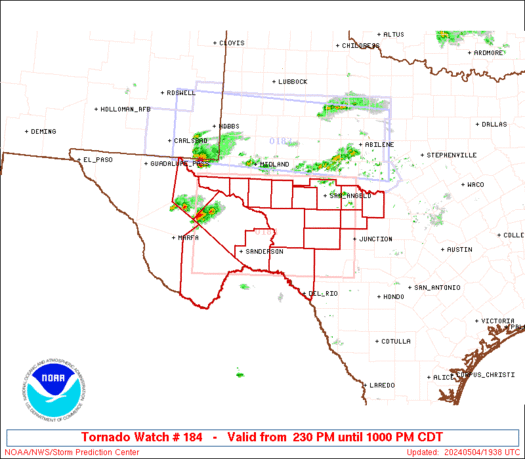
WW 184 TORNADO TX 041930Z - 050300Z
URGENT - IMMEDIATE BROADCAST REQUESTED
Tornado Watch Number 184
NWS Storm Prediction Center Norman OK
230 PM CDT Sat May 4 2024

The NWS Storm Prediction Center has issued a

* Tornado Watch for portions of
  Southwest Texas

* Effective this Saturday afternoon and evening from 230 PM until
  1000 PM CDT.

* Primary threats include...
  A few tornadoes likely with a couple intense tornadoes possible
  Widespread large hail and scattered very large hail events to
    4.5 inches in diameter likely
  Scattered damaging wind gusts to 70 mph likely

SUMMARY...Widely scattered to scattered thunderstorms are forecast
to develop and intensify rapidly this afternoon.  Large to giant
hail will accompany the more intense supercells.  As the stronger
supercells move east into richer low-level moisture in the Pecos
Valley, a greater risk for a few tornadoes is forecast.  The risk
for a strong tornado may maximize during the late afternoon to early
evening timeframe.

The tornado watch area is approximately along and 70 statute miles
north and south of a line from 40 miles west southwest of Fort
Stockton TX to 15 miles north of Junction TX. For a complete
depiction of the watch see the associated watch outline update
(WOUS64 KWNS WOU4).

PRECAUTIONARY/PREPAREDNESS ACTIONS...

REMEMBER...A Tornado Watch means conditions are favorable for
tornadoes and severe thunderstorms in and close to the watch
area. Persons in these areas should be on the lookout for
threatening weather conditions and listen for later statements
and possible warnings.

&&

OTHER WATCH INFORMATION...CONTINUE...WW 183...

AVIATION...Tornadoes and a few severe thunderstorms with hail
surface and aloft to 4.5 inches. Extreme turbulence and surface wind
gusts to 60 knots. A few cumulonimbi with maximum tops to 500. Mean
storm motion vector 26025.

...Smith
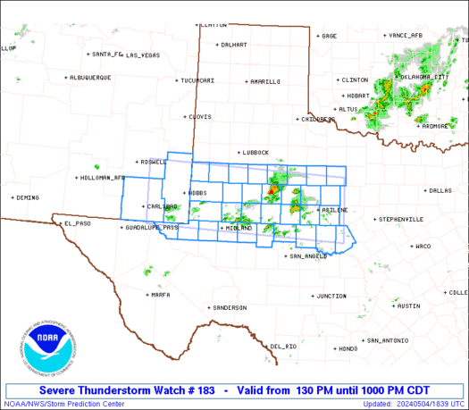
WW 183 SEVERE TSTM NM TX 041830Z - 050300Z
URGENT - IMMEDIATE BROADCAST REQUESTED
Severe Thunderstorm Watch Number 183
NWS Storm Prediction Center Norman OK
130 PM CDT Sat May 4 2024

The NWS Storm Prediction Center has issued a

* Severe Thunderstorm Watch for portions of
  Southeast New Mexico
  West into Northwest Texas

* Effective this Saturday afternoon and evening from 130 PM until
  1000 PM CDT.

* Primary threats include...
  Widespread large hail and isolated very large hail events to 3
    inches in diameter likely
  Scattered damaging wind gusts to 70 mph possible
  A tornado or two possible

SUMMARY...Scattered severe thunderstorms are forecast to develop
this afternoon across portions of the Permian Basin east into the
Texas Big Country.  Elevated supercells will likely pose a large to
very large hail risk.  In closer proximity to the surface boundary,
a risk for severe gusts and perhaps a tornado may develop later
today into the early evening.

The severe thunderstorm watch area is approximately along and 50
statute miles north and south of a line from 55 miles west of Hobbs
NM to 40 miles east of Abilene TX. For a complete depiction of the
watch see the associated watch outline update (WOUS64 KWNS WOU3).

PRECAUTIONARY/PREPAREDNESS ACTIONS...

REMEMBER...A Severe Thunderstorm Watch means conditions are
favorable for severe thunderstorms in and close to the watch area.
Persons in these areas should be on the lookout for threatening
weather conditions and listen for later statements and possible
warnings. Severe thunderstorms can and occasionally do produce
tornadoes.

&&

AVIATION...A few severe thunderstorms with hail surface and aloft to
3 inches. Extreme turbulence and surface wind gusts to 60 knots. A
few cumulonimbi with maximum tops to 500. Mean storm motion vector
26025.

...Smith
WW 0184 Status Updates
STATUS REPORT ON WW 184

THE SEVERE WEATHER THREAT CONTINUES ACROSS THE ENTIRE WATCH AREA.

FOR ADDITIONAL INFORMATION SEE MESOSCALE DISCUSSION 0631

..FLOURNOY..05/04/24

ATTN...WFO...MAF...SJT...EWX...


STATUS REPORT FOR WT 184

SEVERE WEATHER THREAT CONTINUES FOR THE FOLLOWING AREAS

TXC043-095-103-105-235-307-327-371-383-389-413-435-443-451-461-
465-475-042240-

TX
.    TEXAS COUNTIES INCLUDED ARE

BREWSTER             CONCHO              CRANE
CROCKETT             IRION               MCCULLOCH
MENARD               PECOS               REAGAN
REEVES               SCHLEICHER          SUTTON
TERRELL              TOM GREEN           UPTON
VAL VERDE            WARD


THE WATCH STATUS MESSAGE IS FOR GUIDANCE PURPOSES ONLY.  PLEASE
REFER TO WATCH COUNTY NOTIFICATION STATEMENTS FOR OFFICIAL
INFORMATION ON COUNTIES...INDEPENDENT CITIES AND MARINE ZONES
CLEARED FROM SEVERE THUNDERSTORM AND TORNADO WATCHES.
WW 0183 Status Updates
STATUS REPORT ON WW 183

THE SEVERE WEATHER THREAT CONTINUES ACROSS THE ENTIRE WATCH AREA.

FOR ADDITIONAL INFORMATION SEE MESOSCALE DISCUSSION 0631

..FLOURNOY..05/04/24

ATTN...WFO...MAF...SJT...LUB...


STATUS REPORT FOR WS 183

SEVERE WEATHER THREAT CONTINUES FOR THE FOLLOWING AREAS

NMC015-025-042240-

NM
.    NEW MEXICO COUNTIES INCLUDED ARE

EDDY                 LEA


TXC003-033-049-059-081-083-115-135-151-165-169-173-207-227-253-
263-301-305-317-329-335-353-399-415-417-431-433-441-445-447-495-
501-042240-

TX
.    TEXAS COUNTIES INCLUDED ARE

ANDREWS              BORDEN              BROWN
CALLAHAN             COKE                COLEMAN
DAWSON               ECTOR               FISHER
GAINES               GARZA               GLASSCOCK
HASKELL              HOWARD              JONES
KENT                 LOVING              LYNN
MARTIN               MIDLAND             MITCHELL
NOLAN                RUNNELS             SCURRY
SHACKELFORD          STERLING            STONEWALL
MD 0632 CONCERNING SEVERE POTENTIAL...WATCH UNLIKELY FOR EASTERN OKLAHOMA...NORTHERN ARKANSAS...AND SOUTHERN-EAST-CENTRAL MISSOURI
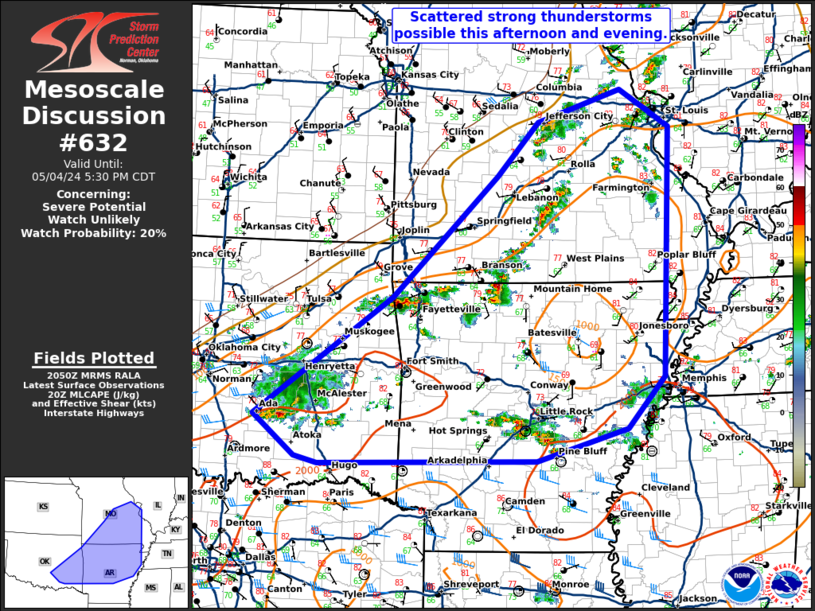
Mesoscale Discussion 0632
NWS Storm Prediction Center Norman OK
0353 PM CDT Sat May 04 2024

Areas affected...eastern Oklahoma...northern Arkansas...and
southern-east-central Missouri

Concerning...Severe potential...Watch unlikely

Valid 042053Z - 042230Z

Probability of Watch Issuance...20 percent

SUMMARY...Scattered strong thunderstorms are possible this afternoon
and evening from eastern Oklahoma across northern Arkansas and into
Misosuri.

DISCUSSION...Scattered thunderstorms have developed along and ahead
of a cold front from eastern Oklahoma into northwest Arkansas and
into Missouri. The airmass ahead of this cold front is moderately
unstable with MLCAPE around 1500 to 2000 J/kg. Effective shear is
relatively weak (<30 knots per SPC mesoanalysis), but VWPs closer to
the cold front (INX and SGF) are sampling greater 0-6 km shear
between 25 and 30 knots. This, in addition to low-level convergence,
will support more robust updrafts near the cold front. A few strong
to isolated severe storms will be possible this afternoon. However,
height rises and broad synoptic scale subsidence should preclude a
more organized severe weather threat and the need for a watch.

..Bentley/Smith.. 05/04/2024

...Please see www.spc.noaa.gov for graphic product...

ATTN...WFO...PAH...MEG...LSX...LZK...SGF...SHV...TSA...OUN...

LAT...LON   34759676 36299458 37879291 38589225 38999092 38509013
            35279027 34599085 34189229 34139574 34229611 34759676
MD 0631 CONCERNING TORNADO WATCH 183...184... FOR SOUTHWEST TEXAS
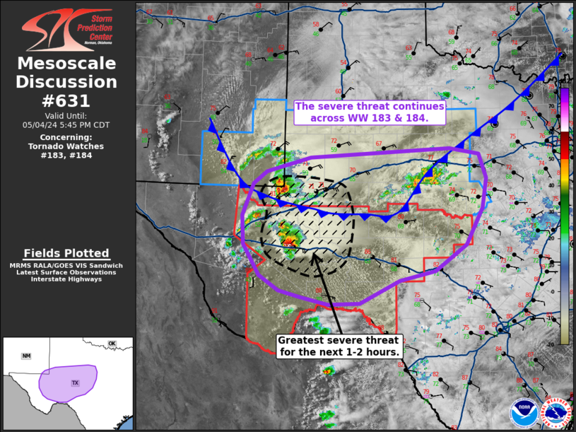
Mesoscale Discussion 0631
NWS Storm Prediction Center Norman OK
0347 PM CDT Sat May 04 2024

Areas affected...Southwest Texas

Concerning...Tornado Watch 183...184...

Valid 042047Z - 042245Z

The severe weather threat for Tornado Watch 183, 184 continues.

SUMMARY...The severe threat continues across much of severe
thunderstorm watch 183 and tornado watch 184 over west/southwest
Texas. The greatest severe weather potential will likely be focused
along and north of the I-10 corridor for the next couple of hours.

DISCUSSION...20 UTC surface observations and visible/radar imagery
continue to show a cold front migrating south across western TX into
a moderately to strongly buoyant air mass. Towering cumulus denoting
substantial lift is noted along the boundary, which will maintain
the potential for additional thunderstorm development heading into
the late afternoon hours. Just behind/along the front, a
well-organized supercell over Winkler County, TX appears to be
displaced slightly to the cool side of the boundary.
Although this cell may be slightly undercut by the front,
temperatures in the upper 60s/low 70s may still support sufficient
surface-based buoyancy based on RAP forecast soundings.
Northeasterly surface winds will help elongate low-level hodographs,
promoting favorable helicity for storm organization and large/very
large hail production and some tornado threat as the cell tracks
east.

Ahead of the front, discrete supercells that initiated off of the
Davis Mountains continue to mature and become better organized as
they migrate deeper into the warm sector. Daytime heating combined
with elongating deep-layer hodographs ahead of an approaching upper
disturbance will promote an increasingly favorable environment for
severe convection. Consequently, further intensification of these
cells is anticipated in the coming hours with the potential for very
large hail (2-4 inches in diameter) and tornadoes. The expectation
for the next couple of hours is that the greatest severe threat will
be associated with (and downstream of) both the post-frontal Winkler
county supercell and the open warm sector convection.

Further to the northeast closer to the I-20 corridor (Big Country),
clustered convection developing along the front will pose a severe
hail risk, but the potential for destructive storm interactions may
modulate the overall severe threat.

..Moore.. 05/04/2024

...Please see www.spc.noaa.gov for graphic product...

ATTN...WFO...FWD...EWX...SJT...MAF...

LAT...LON   30390357 30950391 31470394 32050371 32270342 32530249
            32699954 32589892 32139876 31599886 30939921 30479986
            30300061 29880146 29870211 29990268 30110316 30390357
SPC 2000Z Day 1 Outlook

Day 1 Convective Outlook
NWS Storm Prediction Center Norman OK
0258 PM CDT Sat May 04 2024

Valid 042000Z - 051200Z

...THERE IS AN ENHANCED RISK OF SEVERE THUNDERSTORMS FOR WEST
TEXAS...

...THERE IS A SLIGHT RISK OF SEVERE THUNDERSTORMS ACROSS PORTIONS OF
NORTHWEST/WEST-CENTRAL ILLINOIS...

...SUMMARY...
Scattered severe thunderstorms are expected across parts of the
southern High Plains into the Hill Country of central Texas this
afternoon and evening. Several storms may produce very large hail,
and a couple strong tornadoes are possible.

...20Z Update...

...Far West Texas into TX Hill Country/Central TX...
Outflow-augmented cold front continues to surge southward across the
Permian Basin. Development along the front has been relatively
short-lived thus far, primarily due to the undercutting of the
updrafts. Even so, buoyancy is building north of the front, so more
storm maturation and increasing severe potential appears possible
north of the front. A more thermodynamically favorable environment
exists south of the surging cold front, where there is a greater
potential for surface-based storms capable of all severe hazards,
including tornadoes.

This initially more discrete activity will likely increase in
coverage later this evening as the shortwave trough currently moving
through northern Mexico reaches Far West Texas. Some potential for
upscale growth exists as forcing increasing, with the resulting MCS
then pushing eastward through the Hill Country. Damaging wind gusts
will be the primary hazards with this convective line. However,
ample low-level moisture and veering low-level flow could support a
few line-embedded QLCS tornadoes.

...Western Illinois...
As mentioned in recently issued MCD #630, the airmass ahead of the
southeastward-progressing cold front will continue to destabilize as
dewpoints climb into the mid-60s and temperatures warm into the low
80s. Substantial instability (~1500-2000 J/kg MLCAPE) and modest
deep-layer shear will lead to some loosely organized multicell
thunderstorms capable of isolated hail and damaging gusts along and
ahead of the front later this afternoon.

..Mosier.. 05/04/2024

.PREV DISCUSSION... /ISSUED 1142 AM CDT Sat May 04 2024/

...TX/southern OK/extreme southeastern NM...
Not much change for this outlook update other than a minor southward
shift of severe probabilities across far southeast NM and West TX to
account for the projected cold front position by mid afternoon.
Still expecting widely scattered to scattered thunderstorms to form
this afternoon along and behind the cold front over west TX and
southeastern NM, as well as ahead of the cold front, near the
dryline and over strongly heated, relatively high elevations west of
the Pecos Valley.  The stronger updrafts will attain supercell
characteristics and pose a large-hail threat on both sides of the
front, with severe-wind and tornado potential more prevalent to its
south.  Forecast soundings south of the front indicate veering and
increasing flow with height which will become very favorable for
supercells.  It still appears one or two dominant, prefrontal,
mid/late-afternoon supercells may evolve and remain south of the
front.  The potential for a strong tornado in addition to giant hail
will be the primary hazards with these warm sector supercells.
Additional storm development is expected by early evening with an
amassing of cold pools eventually expected, as southeasterly 850mb
flow strengthens.  A severe MCS will likely evolve during the
evening and probably persist into the overnight as it moves east
across portions of the Edwards Plateau and central TX.  Have
expanded wind probabilities farther east to account for a lingering
threat for severe gusts and perhaps a localized risk for a tornado
late as this activity moves east of I-35.

...North/northeast TX to mid Mississippi Valley/western Great Lakes
vicinity...
A diurnal intensification of isolated to scattered thunderstorms is
expected this afternoon within this general corridor from the Red
River Valley northeastward into the IL/WI vicinity.  With much of
this region located in between larger-scale mid-level waves, modest
kinematic fields will tend to limit overall storm organization and
severe potential.  Nonetheless, heating of a moist boundary layer
will facilitate the development of moderate instability by early to
mid afternoon.  Mainly semi-organized bands of multicells and
clusters thereof will occasionally result in sporadic potential for
wind damage and large hail.  It appears perhaps a corridor for
greater wind damage potential may occur immediately ahead/downstream
of an MCV moving east across the mid MS Valley.  Model guidance
indicates slightly greater organized line segments and wind
potential later this afternoon from central into northern portions
of IL.  Have also expanded the MRGL northward into portions of WI
where sufficient destabilization will occur ahead of a front and
associated mid-level disturbance over the Upper Midwest.
SPC 1730Z Day 2 Outlook

Day 2 Convective Outlook
NWS Storm Prediction Center Norman OK
1230 PM CDT Sat May 04 2024

Valid 051200Z - 061200Z

...THERE IS A SLIGHT RISK OF SEVERE THUNDERSTORMS FROM THE TEXAS
HILL COUNTRY INTO THE MIDDLE TEXAS COASTAL PLAIN...

...SUMMARY...
Strong to severe thunderstorms may occur Sunday across parts of the
southern Plains into the ArkLaTex and Mid-South, and separately over
portions of Ohio into western Pennsylvania. Highest severe
thunderstorm potential is expected from the Texas Hill Country into
the Middle Texas Coastal Plain.

...Synopsis...
A southern-stream shortwave trough, likely enhanced somewhat by
widespread thunderstorms Saturday night, is expected to begin the
period extended from central OK through southeast TX. This shortwave
is forecast to make steady northeastward progress throughout the
day, reaching the Lower OH Valley by late Sunday night/early Monday
morning. A separate north-stream shortwave trough will likely will
move across Ontario and western Quebec, with an attendant surface
low moving just ahead of this wave. An associated cold front will
extend southwestward from this low, and is expected to progress
eastward across the OH Valley throughout the day. Southern portion
of this front (i.e. from the Mid-South into central TX) will remain
largely stationary throughout the day, before then transitioning to
a warm front amid strengthening return flow overnight.

Farther west, a deep upper cyclone is forecast to progress eastward
across the Great Basin before devolving into more of an open wave as
it moves through the central Rockies and into the central High
Plains. Strong mid-level flow will accompany this system, spreading
eastward and reaching the southern/central High Plains by early
Monday morning.

...Southern Plains into the ArkLaTex and Mid-South...
Showers and thunderstorms will likely be ongoing from eastern OK
into central and southeast TX at the start of the period early
Sunday morning, although with varying convective modes.  A more
linear, modestly organized convective line may be ongoing across
southeast TX, remnant from Saturday night/early Sunday morning
activity across central TX. Gradually decreasing buoyancy should
lead to gradual weakening of this line as it moves into
west-central/southwest LA. Even so, given the potentially organized
character to the line, some damaging gust will still be possible.

A more multicellular mode is anticipated throughout the day from
eastern OK into the Arklatex and Mid-South, supported by persistent
forcing for ascent and modest buoyancy. A few stronger updrafts
capable of hail are possible, with some limited potential for a few
bowing segments capable of damaging gusts as well.

Farther west, an outflow boundary is expected to extend westward
from this decaying convective line, likely from the middle TX
Coastal Plain through the Hill Country into the Edwards Plateau.
This boundary will likely provide the focus for addition
thunderstorm activity during afternoon. Ample low-level moisture,
strong buoyancy, and moderate deep-layer shear support the potential
for supercells with any discrete development. Large hail is primary
hazard with initial development, but some trend towards upscale
growth is likely, with the resulting convective line tracking along
the outflow boundary. Mesoscale nature of this scenario does lead to
some uncertainty, particularly on the location of the outflow
boundary, but guidance is consistent enough to delineate higher
probabilities from the TX Hill Country into the Middle TX Coastal
Plain.

...Ohio into Western Pennsylvania...
As mentioned in the synopsis, a weak front is forecast to move
eastward across the OH Valley Sunday. Modest destabilization should
occur ahead of this front across OH and western PA, contributing to
the potential for isolated to scattered thunderstorms along and
ahead of this boundary. Deep-layer shear of 20-30 kt should support
marginal updraft organization, with occasionally strong to damaging
gusts as these storms spread east-southeastward across parts of OH
into western PA and vicinity Sunday afternoon and early evening.
This activity should gradually weaken through the evening across PA
as it encounters a less unstable airmass.

...Northern High Plains...
Despite limited low-level moisture and scant buoyancy, increasing
mid-level moisture and strengthening large-scale forcing for ascent
ahead of the Great Basin shortwave is forecast to support the
development of isolated thunderstorms late Sunday evening. Given the
high storm bases and strengthening mid/upper flow, a few strong
gusts are possible. Even so, the overall severe threat appears too
limited to include low severe probabilities with this outlook.

..Mosier.. 05/04/2024
SPC Day 3-8 Fire Weather Outlook

Day 3-8 Fire Weather Outlook
NWS Storm Prediction Center Norman OK
0334 PM CDT Sat May 04 2024

Valid 061200Z - 121200Z

An active fire weather pattern remains on track through at least
midweek across the southern Rockies extending eastward into the
southern High Plains.

... Monday/Day 3 to Wednesday Day 5: New Mexico into adjacent parts
of Texas and Colorado ...

A strong, negatively tilted trough will eject into the Plains during
the day on Monday. In its wake, strong mid-level flow will exist
across New Mexico into the central Plains. The orientation of this
flow will result in strong downslope flow across the region. The
result will be surface winds approaching 30 mph in the presence of
relative humidity beneath 15 percent. Extremely critical
meteorological conditions will be possible across northeast New
Mexico; fuel receptiveness will be the limiting factor for fire
potential.

By Tuesday into Wednesday, strong westerly mid-level flow will
persist atop a dry boundary layer. This will continue the downslope
flow, with winds around 20 mph. Relative Humidity will continue to
fall into the single digits and teens resulting in continued fire
weather concerns.

Toward the latter half of the week, the mid-level flow will relax a
bit. Elevated fire weather conditions will remain possible, but
confidence in critical conditions being met is less than in previous
days. Trends will need to monitored as mesoscale details come more
into focus.

..Marsh.. 05/04/2024

...Please see www.spc.noaa.gov/fire for graphic product...
|